
| <<<< Back to Apple Site |
Day 1: from La Chapelle
d'abondance to Refuge de Bise
After nine-and-a-half hours driving arrived at La Chapelle d'abondance
(3300 ft). Up woods along the GR5 (path) to the Pas de la Bosse (5950
ft) and then dropped down to Refuge de Bise (4930 ft). The refuge is a
fairly spartan affair. The toilet (there is only one) is a hole in the
floor
with four planks around it and the washing facilities are a
hollowed-out tree-trunk with water in which also serves as a drinking
trough for the goats and cows. At the refuge you always meet some
fellow countrymen who are doing the GR5.
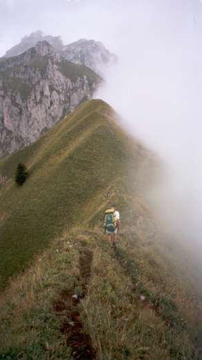
Day 2: Cornettes de Bise.
Beautiful weather today with a clear blue sky. From the Refuge
de Bise to the Pas de la Bosse. This should take 40 minutes. Dolf (my
friend) manages it in 25 minutes. Then left along the flank of
Cornettes de Bise and into the couloir Seroukin. We are not the only
ones today. I quickly make acquaintances with a Frenchman of 70 years,
who is unable to keep up with his group. I'm having difficulty keeping
up with Dolf!. Steeply up woods along endless zigzags between vertical
rocks. Easy scrambling to the top of Cornettes de Bise (7980 ft). You
could see the refuge 3000 ft below. A fantastic view towards Lac Leman
and the Jura in the north, and the Dents du Midi and Mont Blanc in the
south, possibly the Matterhorn in the East (or am I mistaken). Up here
we have mobile phone reception and are able to inform our families that
we have arrived safely. The trouble is if you move it switches from the
French provider to the Swiss provider! We drop down on the east side to
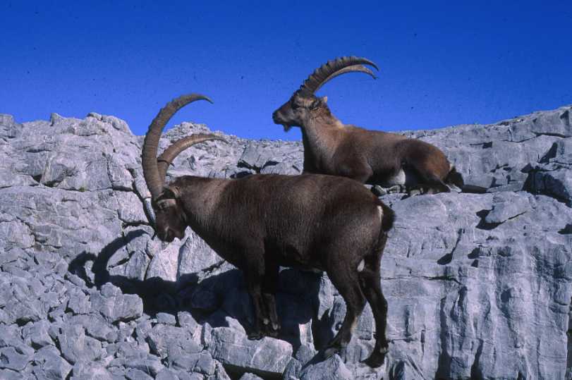
col du Millieu. Following the path down into chaux de Millieu. A lot of
ibex. On to montagne de l'Au and col d'Ugeon (6600 ft). An hours rest
in the sun lying on the grass. Then back down to Refuge de Bise and a
beer.
Day 3: from Refuge de Bise to
Refuge de Dent d'Oche
The odd cloud in the sky. From refuge de Bise to col d'Ugeon (6600 ft).
On the way a stone the size of a football fell on us. We suspect the
ibex. Immediately before the col upwards to Dent du Velan. Over this
and then further along Arete de Charousse. On the way we'd met some
ibex who stood and looked at us from a distance of 15 feet. Of course
by the time I got my camera out they had moved further away. From the
north (Lac Leman) the mist was rising obscuring the view. Along the
crest to Tete de Charousse (6600 ft) and further to col de Bise (6300
ft).
Ibex and Dolf on Arete de Charousse.
Briefly spoke to a group of English
people doing the GR5. They had spent the night at refuge du Dent d'Oche
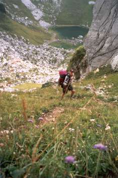
and waxed lyrical over the view in the morning. Then via Col de Pavis
(6400 ft) to lac de Darbon (6000 ft). Here we could smell chives. After
a little investigation we discovered chive plants on the banks of the
lake. After a rest by the lake, onwards and steeply upwards to Les
portes d'Oches (6400 ft) and continuing to Lac de la Case (5700 ft).
Ascending from Lac de Darbon
Bearing right to Col de Planchamp
(6500 ft). By now we are in the mist. Bearing left just before the col
on to the flanks of Dent d'Oche. It begins to rain. Up further to the
summit of Dent d'Oche (7300 ft). It appears that it is normal to
traverse this route in the opposite direction as we keep having to move
aside to allow people to pass. A rest on the summit. Suddenly a clap of
thunder. This we had not expected. A thunderstorm on a ridge is not
exactly desirable! Fortunately the hut is nearby, only 500 ft below us
on the west side. Speedily but carefully, since the north face of Dent
d'Oche is very high and steep, we press on along the ridge. The refuge
is nowhere to be seen through the mist and rain. You'd think you
couldn't miss it. More thunder. The path divides into two. What now.
That is totally illogical. Another thunderclap. Then to the right and
below me I hear a door slam. Yes! At last the refuge Dent d'Oche. (6800
ft). Dripping wet we enter through the thick steel door. Apart from us
there are only four blokes from Geneva who want to climb de Dent but
who are stuck here.They are not particularly communicative (perhaps
that is our French). The beer and the cheese fondue taste wonderful.
Too wonderful, since in the night I had to go in search of the WC hut
outside. Still raining.
Day 4: from refuge Dent d'Oche to
Refuge d'Ubine
The day begins with mist and rain. The wonderful morning view we had
been promised from Dent d'Oche was not to be seen. In frustration I
bought a postcard which I have scanned in (see below).
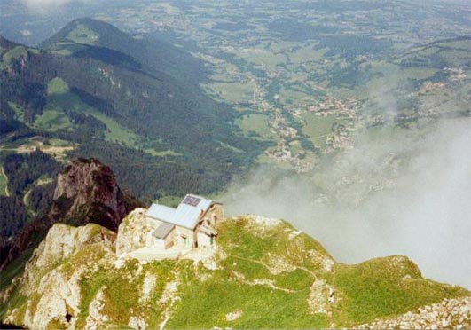
Refuge du Dent d'Oche (scanned photo)
From the refuge (6800 ft) down to the
chalets d'Oche (approximately 5100 ft). We almost missed the chalets in
the mist but were saved by a prominent yellow waymark. Left towards Lac
de la Case (5700 ft). There we turned left to Col de Case d'Oche (6000
feet). It stops raining. Drop down to the hamlet of Darbon (5200 ft).
It is like a ghost town.... No one
to be seen. Carried on after lunch, via a beautiful quiet and deserted
dale, up to a nameless col (5900 ft) on to the flanks of Mont de
Chillon. First through the meadows then through a wood until a cow
blocked the way. The bog on either side prevented us from getting past.
Then as we tried to shoo her away, with much waving of arms, she stood
in front of us and defecated. We were standing close to each other on a
relatively steep slope and were unable to jump out of the way. The
excrement splashed all over our shirts and trousers. On the col, time
for a bar of chocolate and a change of shirt. The mist gradually
cleared. It is still cloudy however. Now we drop down to Lac
Fontaine (4400 ft). Tea and a snack in a pleasant restaurant. We dry
our socks in front of the blazing wood fire. A welcome relief after a
wet day. An hour later we leave for Ubine, via Les Maupas
(approximately 4900 ft). A lovely route through woods. On the way we
gorge on raspberries and blueberries. When we arrived at Refuge d'Ubine
(4900 ft) a birthday party for the 'madame de gardien' was in full
swing. Singing, drinking and fanatic dancing. Of we are given a beer.
There are showers here. What a luxury! We have to hurry since another
group of Dutch people have just arrived and are also longing for hot
water. The meal is fantastic although we still don't know what it was.
It is not busy and we have the dormitory for ourselves and we are able
to hang everything up to dry.
Day 5: from Refuge d'Ubine to La Chapelle d'abondance
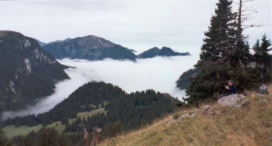
Up early after a good night. Clouds cover the valley below although
here and there the sky is blue. Our actual plan was to travel via col
de la plagne to the summit of Mont Chauffe (6900 ft) but the uncertain
weather (although this later turned out not to be so bad since the
clouds remained hanging in the valley below) made us decide on an
alternative route; direction Les Maupas, but, before reaching there,
heading across fields to the ridge, over this ridge (in places quite
narrow) to Pointe de Lachau (6400 ft).
Dolf, on the ridge on the way to Pointe de Lachau.
After this descending from the ridge to
col d'Ubine (5600 ft), where we met the group of Dutch people again,
and then via Chalets de Mens back to the car-park by "Chalets de
Chevenne" (4000 ft).
The
Fauna
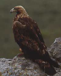
The golden eagle, Aquila chrysaetos in latin, steenarend in Dutch.
In French "Aigle royale". Wingspan up to 2.2 metres! Weight up to
14 lbs! They may live as long as 15 to 20 years. Eagles now live almost
exclusively in mountainous regions. They hunt for small mammals such as
the alpine marmot, hares, foxes, weasels, and small birds. They dive
onto their prey at speeds reaching 100 mph. Throughout the world they
are a protected species. The alpine population is now stable.
Golden
Eagle
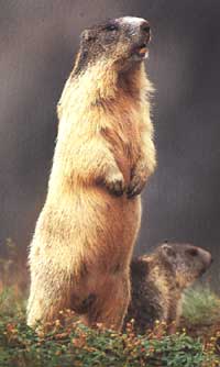
There are also a lot of marmots in the Alps. They live above
the tree line, usually on south facing slopes. It is a large rodent. 16
- 20 inches long. They can weigh between 8 and 18 lbs. They live up to 18
years. They are related to the squirrel family. They live in colonies,
inn holes under the rocks. In August they collect dried plants and
grass with which they line their nest to protect themselves against the
cold during hibernation. They eat seeds, roots, herbs and grasses.
Marmot
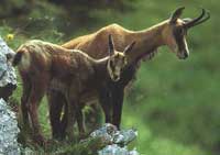
A lot of chamois could also be seen near the refuge. One even dared
to approach to within 50 feet. There are about 500 of them in this area.
When the chamois hear the call of the marmots they quickly flee for
safety. They are very shy animals. The chamois grow up to thirteen feet
in height and jump up to 24 feet high! They can be recognised by their
small pointed curved horns and a white spot on their backside. They
live high in the mountains, but lower than the ibex, and generally
around the tree line.
Chamois
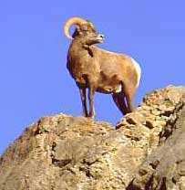
You can also see mouflon in this area which are often
mistaken for ibex. They also have a large horns but these are much more
curved, up to 180 degrees. The female has no horns. The mouflon is a
wild sheep. Although it became extinct in the Alps during the Ice Age
it was re-introduced from Corsica and Sardinia. In fact, I have never
seen a mouflon in this particular area but have seen them
further south around Mont Blanc.
Mouflon
Ibex